

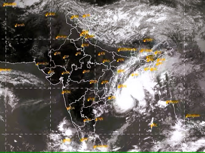
The India Meteorological Department (IMD) issued a statement regarding the cyclonic storm 'Hamoon' which has intensified into a severe cyclonic storm in the Northwest Bay of Bengal. It is expected to continue moving towards the north-northeast. The latest forecasts suggest that the storm will reach Bangladesh as Deep Depression and make landfall on the Bangladeshi coast, specifically between Khepupara and Chittagong, at around noon on October 25, 2023, with considerable strength.
It is expected that there will be light to moderate rainfall in South Assam and eastern Meghalaya on October 24-25, with the possibility of occasional heavy rainfall in South Assam.
The coastal districts of Odisha may experience the influence of Hamoon, leading to light to moderate rainfall at most places on October 24. Likewise, the coastal districts of West Bengal should be prepared for potential weather disturbances. According to the Meteorological Department, light to moderate rainfall is expected in most areas on October 24, with isolated heavy rainfall possible in the coastal regions of West Bengal.
Cyclonic Storm Hamoon is also producing strong winds across the Bay of Bengal and several areas of Eastern India.
Reminder: There will be squally winds (sudden increases in wind speed that last for minutes) in the upcoming days along and off the Odisha coast, with speeds ranging from 40-50 kmph, gusting to 60 kmph. Starting from the morning of October 24, these winds will also affect the West Bengal, Bangladesh, and North Myanmar coasts. Please keep in mind that wind speeds are expected to gradually increase, reaching 55-65 kmph with gusts to 75 kmph along and off the Bangladesh coast, 50-60 kmph with gusts to 70 kmph along and off the North Myanmar coast, and 45-55 kmph with gusts to 65 kmph along and off the West Bengal coast on October 25th.
On October 25, there may be squally winds with speeds ranging from 40-50 kmph, gusting to 60 kmph, prevailing over Mizoram and Tripura. Additionally, we can expect strong winds with speeds of 30-40 kmph, gusting to 50 kmph, over South Assam and Manipur on the same day.
Considering these recent developments, it would be highly recommended that residents in the affected regions remain informed through official advisories and kindly ensure they take the necessary precautions.
You may also read: Cyclone Tej Intensifies: To Turn Into A Severe Cyclonic Storm, Alerts Issued
SCS Hamoon intensified into VSCS about 290 km east of Paradip (Odisha), 270 km southeast of Digha (West Bengal), 230 km south-southwest of Khepupara (Bangladesh). Likely to weaken and cross Bangladesh's coast between Khepupara and Chittagong around the evening of 25th Oct as CS. pic.twitter.com/6moaRNxqwZ — India Meteorological Department (@Indiametdept) October 24, 2023
Image Source: HT
Ⓒ Copyright 2023. All Rights Reserved Powered by Vygr Media.