

On October 2, during Dussehra celebrations at Bhuj, Gujarat, Defence Minister Rajnath Singh issued a sharp warning to Pakistan over the long-standing Sir Creek dispute. “Any misadventure by Pakistan in the Sir Creek sector will invite a decisive response,” he said, adding that such a reply could “change both history and geography.”
His comments come at a time when Pakistan has been expanding its military infrastructure near Sir Creek, a disputed and sensitive estuary along the India-Pakistan border. Singh accused Pakistan of harbouring “ill intentions” in the region, despite India’s repeated efforts to resolve the issue through dialogue. The statement has once again brought the Sir Creek dispute into sharp focus, reviving questions about why this seemingly desolate marshland continues to be a flashpoint between the two nations.

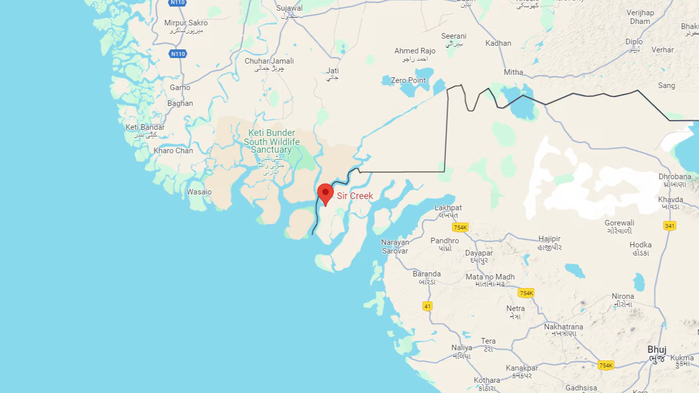
What is Sir Creek?
Sir Creek is a 96-kilometre-long tidal estuary situated in the marshlands of the Rann of Kutch between India’s Gujarat state and Pakistan’s Sindh province. This narrow, muddy strip flows into the Arabian Sea and marks part of the India-Pakistan border. While uninhabited and appearing remote, the creek holds significant importance because it directly impacts maritime boundaries, fishing rights, and potential access to oil and gas reserves.
The dispute essentially centres around how the boundary is to be drawn in the Sir Creek area. Specifically, the demarcation question lies “from the mouth of Sir Creek to the top of Sir Creek, and from the top of Sir Creek eastward to a point on the line designated as the Western Terminus.” Beyond that point, the boundary was defined clearly by the 1968 Tribunal Award following arbitration of the Rann of Kutch conflict.
The Origins of the Dispute
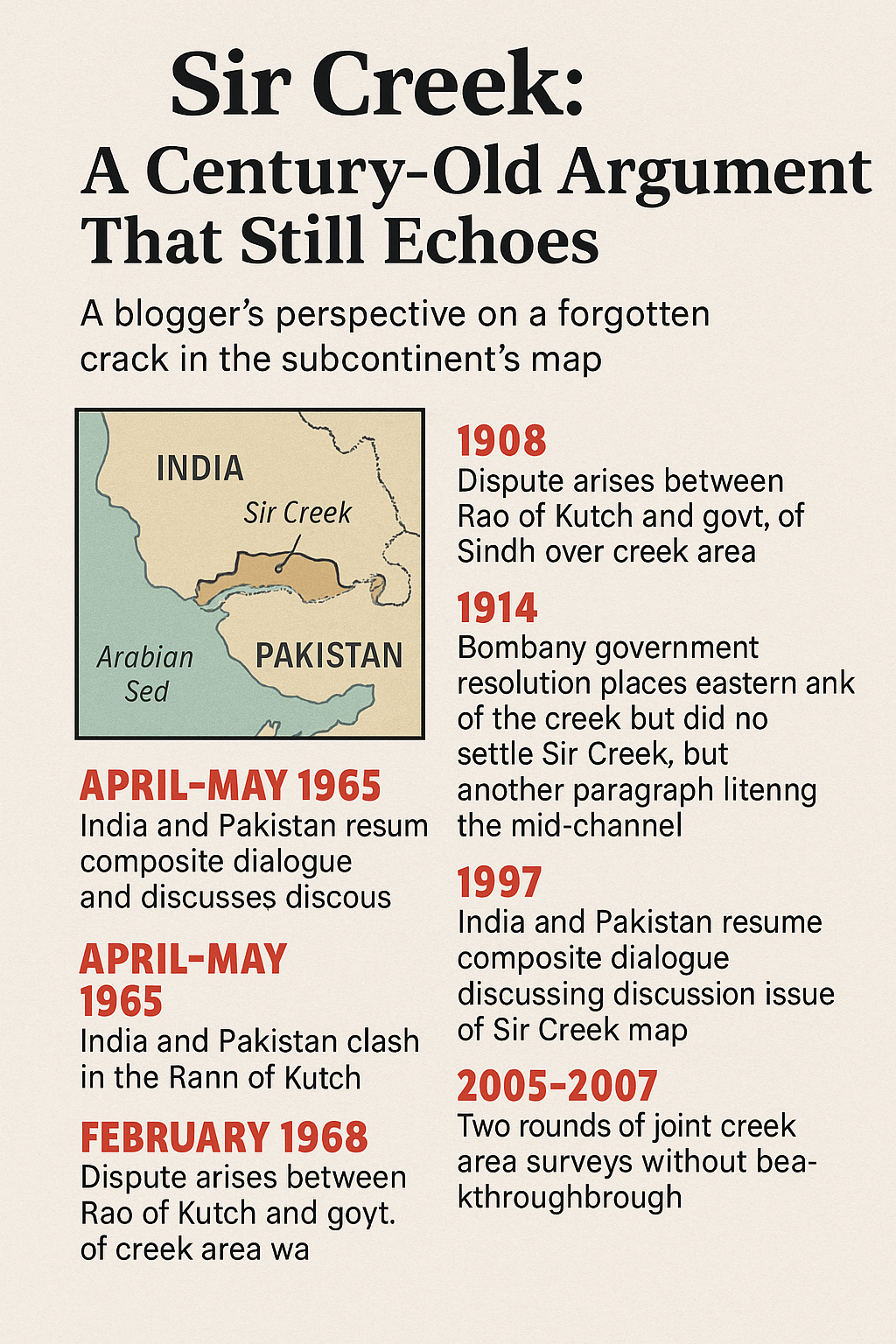
The Sir Creek dispute dates back over a century. In 1908, rulers of the princely states of Sindh and Kutch reportedly quarreled over a pile of firewood on the banks of the creek. The disagreement escalated and eventually drew the intervention of the Bombay Presidency government, which in 1914 attempted to resolve the dispute.
The 1914 resolution, backed by Map Number B44 (and later B74.1), placed the boundary on the eastern bank of the creek, supporting Sindh’s claim. But it also invoked the thalweg principle, which suggests that the boundary should run along the middle of the navigable channel. This contradiction has been the crux of the problem.
-
Pakistan’s position: The entire creek belongs to Sindh, relying on the eastern bank demarcation. Pakistan also argues that the thalweg principle applies only to rivers, not tidal estuaries, and further insists Sir Creek is not navigable.
-
India’s position: The thalweg principle applies, as the creek remains navigable during high tide. India cites the 1914 resolution itself, a 1925 map, and mid-channel boundary pillars as evidence.
After Independence in 1947, Sindh went to Pakistan and Gujarat remained with India, cementing the dispute as an international issue. In the 1960s, tensions resurfaced after clashes over the Rann of Kutch. Pakistan claimed that half of the Rann along the 24th parallel was its territory. India countered this claim, leading to arbitration.
The Indo-Pakistani Western Boundary Case Tribunal delivered its verdict on February 19, 1968. The award went heavily in India’s favour, granting it 90% of the disputed Rann of Kutch while conceding some areas to Pakistan. However, Sir Creek remained unresolved because both parties had agreed to keep that portion out of the tribunal’s scope.
Why Does Sir Creek Matter?
Although the marshy strip has limited military significance, its economic and strategic importance is undeniable.
-
Maritime Boundaries and EEZs: Control over Sir Creek determines how maritime boundaries are drawn. A shift of just a few kilometres can alter the Exclusive Economic Zones (EEZs) and continental shelf claims of both countries in the Arabian Sea. These zones are crucial for fishing rights, resource exploration, and naval operations.
-
Oil and Gas Reserves: The region is believed to hold untapped oil and gas reserves. Ownership of Sir Creek directly influences who can exploit these resources.
-
Impact on Fisherfolk: Thousands of fishers in Gujarat and Sindh unknowingly cross the disputed waters. Both nations often arrest these fishers, holding them for years despite international law recommending minimal penalties. This has long caused humanitarian concerns and strained bilateral relations.
-
Environmental Factors: Pakistan’s Left Bank Outfall Drain (LBOD) canal discharges saline and industrial wastewater into Sir Creek. India views this as a violation of the Indus Waters Treaty, adding another layer of contention.
Attempts at Resolution
Over the decades, India and Pakistan have held multiple rounds of talks on the Sir Creek issue, including under the composite dialogue framework.
The last formal dialogue on the issue took place in June 2012, where the two sides discussed the land boundary around Sir Creek and delimitation of the maritime boundary.
In December 2015, the two nations agreed to revive a Comprehensive Bilateral Dialogue that included Sir Creek. However, the January 2016 terror attack on the Pathankot Airbase derailed this process.
The Ministry of External Affairs reiterated in 2019 that Sir Creek remains on the bilateral agenda, but Pakistan’s continued support for cross-border terrorism has prevented structured dialogue.
Rising Tensions and Military Build-Up
Since 2019, Pakistan has accelerated its military presence in the Sir Creek region. Reports indicate it has deployed:
-
New Creek Battalions
-
Coastal defence boats
-
Marine assault crafts
-
Surveillance radars, missiles, and aircraft for air defence
India, wary after the 2008 Mumbai terror attacks that were launched via sea, has also strengthened its presence. In 2018, the BSF seized boats in the creek to check infiltration threats. In 2019, abandoned boats in the area prompted terror alerts.
This steady militarisation has raised alarms in New Delhi. Rajnath Singh, during his recent address, warned Pakistan: “In 1965, the Indian Army demonstrated that it was capable of reaching Lahore. Today, in 2025, Pakistan must remember that one route to Karachi passes through the creek.”
Rajnath Singh’s Warning and Operation Sindoor
During the Dussehra address in Bhuj, Singh not only performed the traditional shastra puja (worship of weapons) with soldiers but also spoke extensively about Pakistan’s “ill intentions.”
He said: “Any misadventure by Pakistan in the Sir Creek sector will invite a decisive response. If Pakistan dares to act in the Sir Creek sector, the reply will be so strong that it will change both history and geography.”
He reminded Pakistan of past wars, noting: “In 1965, the Indian Army reached Lahore. In 2025, Pakistan must remember that the road to Karachi also passes through the creek.”
Singh also lauded the armed forces for their success in Operation Sindoor (May 7–10). He explained how Pakistan attempted to penetrate India’s defences along the Line of Control and International Border—from Leh to Sir Creek—using drones and missiles. The Indian response not only neutralised the threat but also “exposed the weaknesses of Pakistan’s air defence system.”
He clarified that Operation Sindoor’s objective was to target terrorism infrastructure, not to escalate conflict: “Our fight against terrorism continues. The objective of Operation Sindoor was not to start a war, but to neutralise threats. The armed forces achieved all objectives successfully.”
Additionally, Singh inaugurated a tidal-berthing facility and a Joint Control Centre in the Sir Creek sector to boost maritime security.
Final Thoughts
The Sir Creek dispute, while rooted in history, continues to carry immense strategic, economic, and security implications for both India and Pakistan. What may look like a narrow, uninhabited strip of land is in fact a geopolitical hotspot tied to resources, fishing rights, and maritime control.
India has consistently sought to resolve the issue through dialogue, but Pakistan’s stance, coupled with its expansion of military infrastructure, has kept the dispute alive for over seven decades. Rajnath Singh’s sharp warning underscores India’s resolve to defend its territorial and maritime interests decisively if provoked.
In Singh’s words, the road to Karachi “passes through Sir Creek”—a symbolic reminder that while India remains committed to peace, it will not hesitate to act with strength when its sovereignty is challenged.
With inputs from agencies
Image Source: Multiple agencies
© Copyright 2025. All Rights Reserved. Powered by Vygr Media.