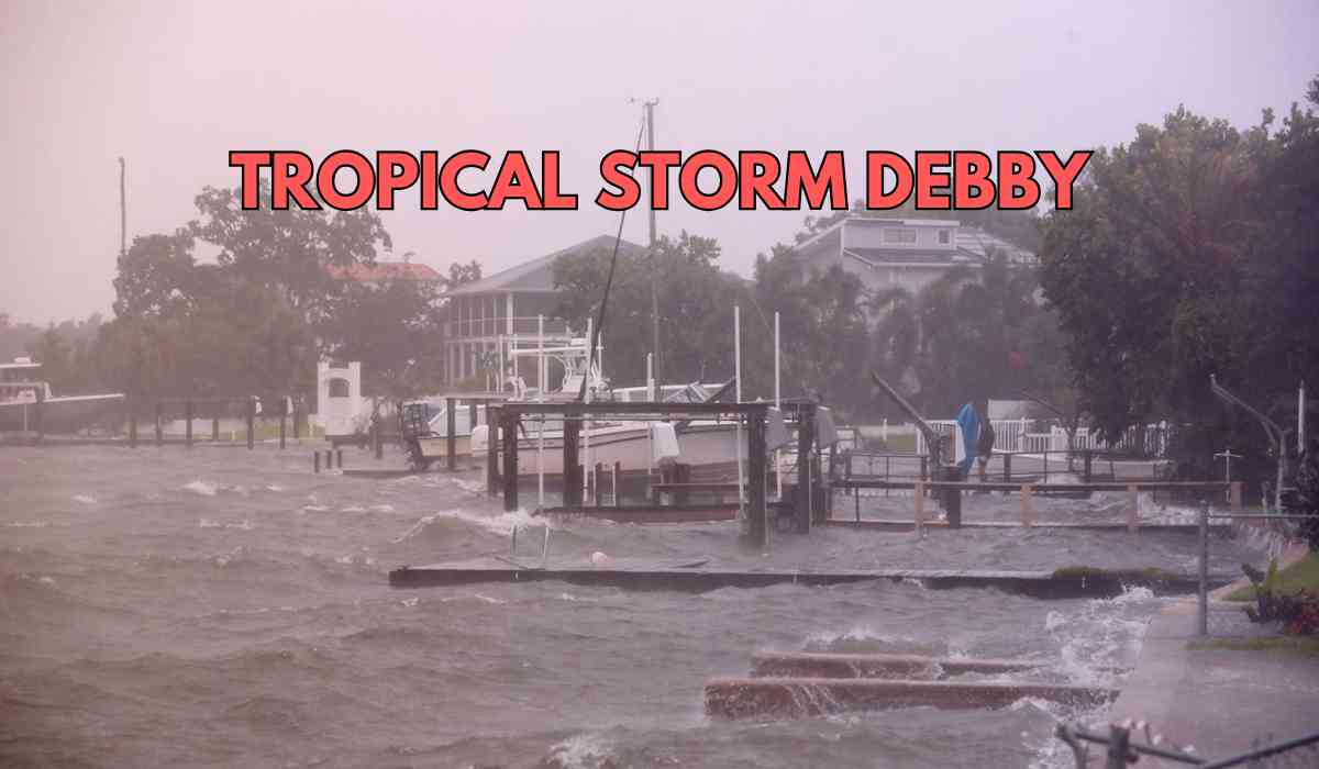

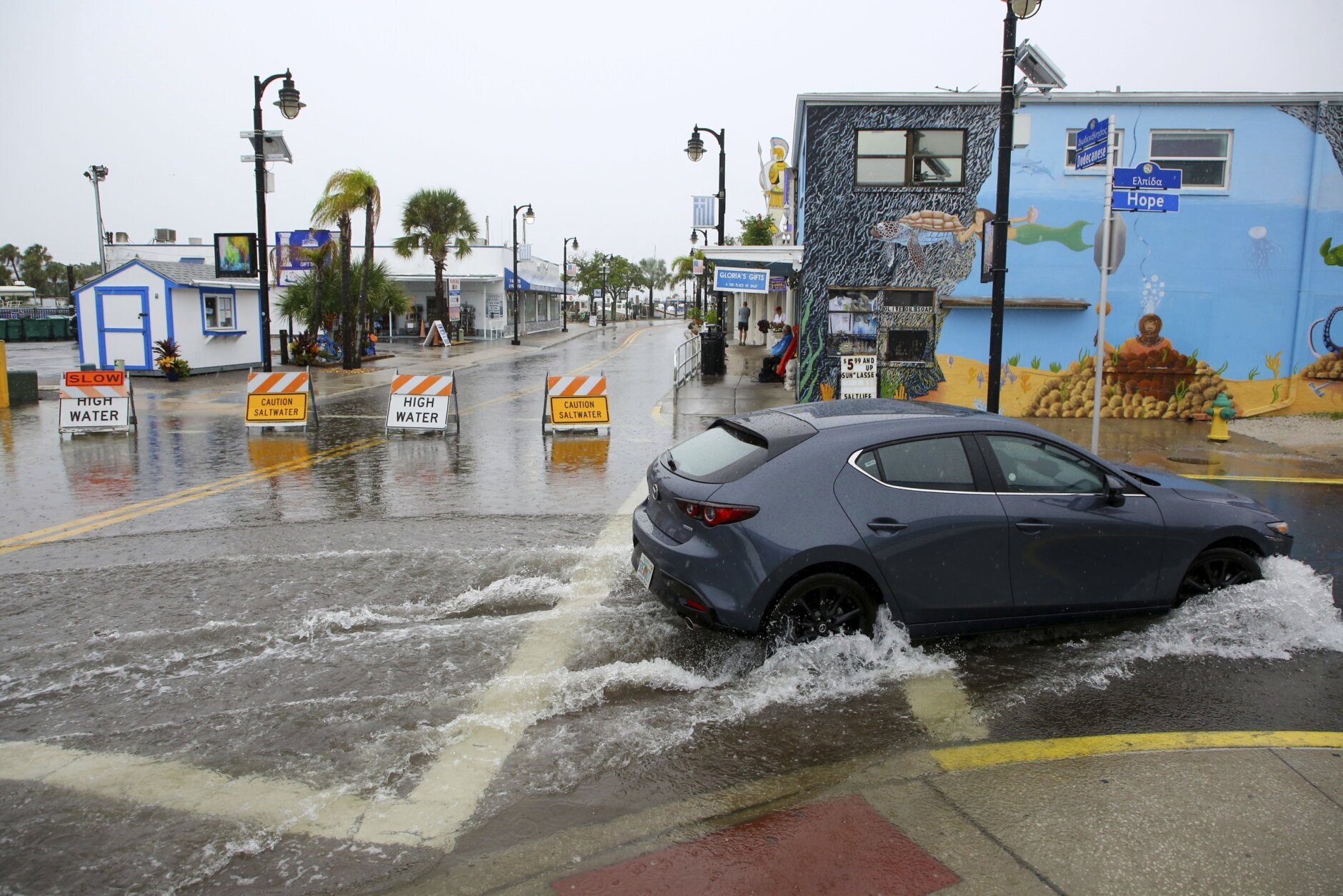
Hurricane Debby emerged in the Gulf of Mexico on Sunday night. The storm, which initially took shape over the warm waters of the Gulf, is currently advancing towards the Big Bend region of North Florida. The National Hurricane Center (NHC) has released advisories indicating that significant flooding is anticipated upon Debby’s landfall.
State of Emergency Declared by Florida Governor DeSantis
In preparation for Hurricane Debby, mandatory evacuation orders have been issued for several counties including Alachua, Citrus, Dixie, Franklin, Levy, Taylor, and Wakulla.
In response to the looming storm, Florida Governor Ron DeSantis declared a state of emergency on Thursday for 54 counties, preparing for what could be the first significant threat to the state. Following updates on Friday night, an additional seven counties were included, bringing the total to 61 out of Florida’s 67 counties now under a state of emergency.
Atlantic Hurricane Season
-
Duration
The Atlantic hurricane season spans from June 1 to November 30 each year. This period marks the time when conditions are most favorable for the formation and intensification of hurricanes in the Atlantic Ocean.
-
Peak of the Season
The peak of the Atlantic hurricane season occurs around September 10. Historically, the most intense hurricane activity tends to happen between mid-August and mid-October. This period is crucial for monitoring and preparing for potential storm threats.
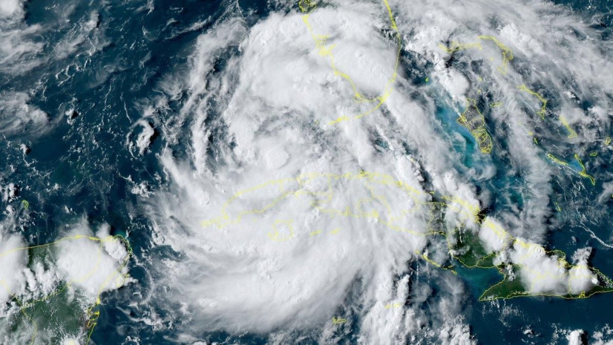
➤ Spaghetti Models for Hurricane Debby
The NHC has highlighted the possibility of life-threatening storm surges along portions of Florida's Gulf Coast. As Debby is a Category 1 hurricane, further strengthening is anticipated. Governor Ron DeSantis has warned that wind gusts could reach 85-90 mph, with North Florida potentially experiencing catastrophic rainfall amounts between 15 to 20 inches.
➤ Where is Hurricane Debby?
-
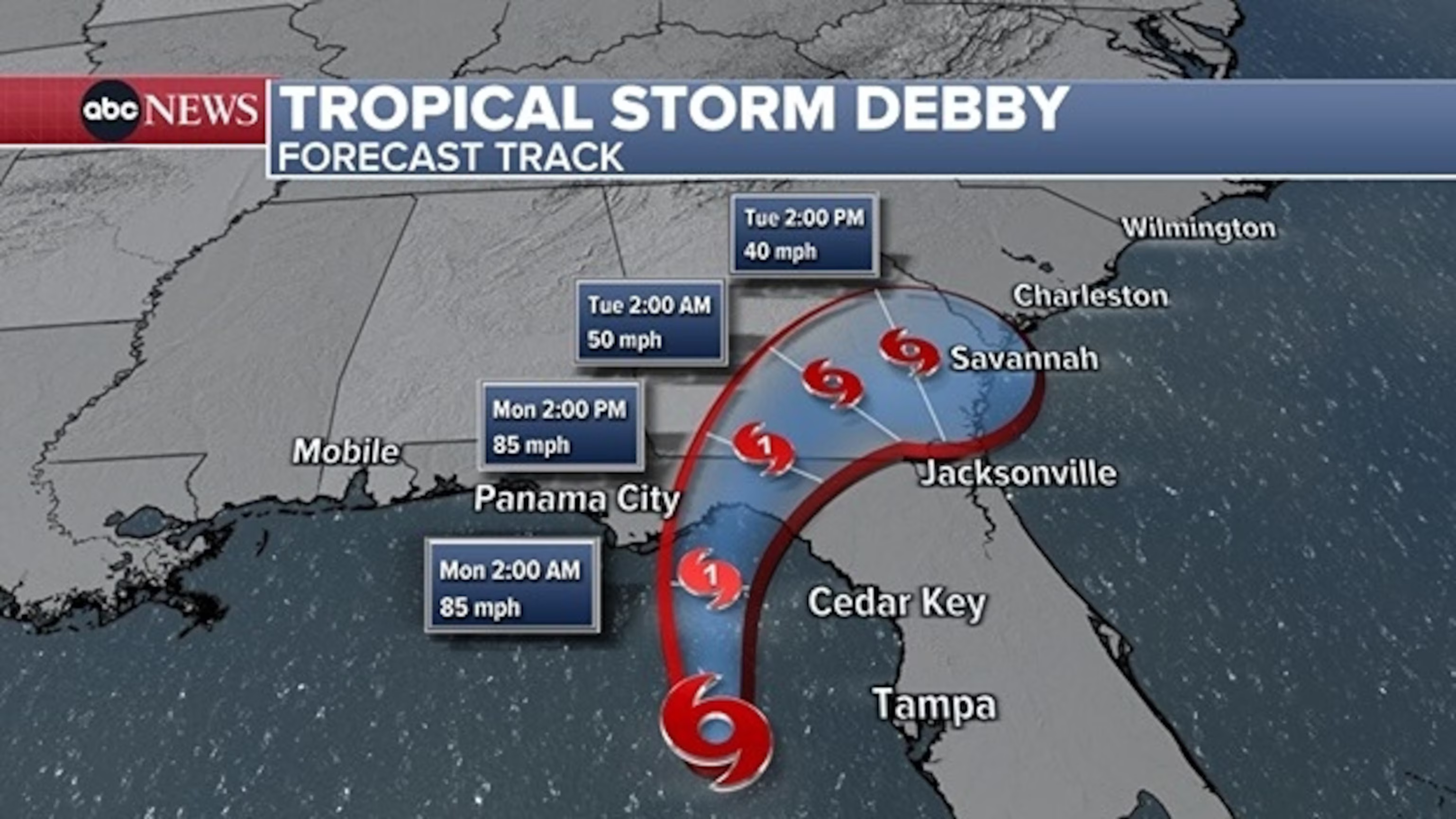
Location: 65 miles west-southwest of Cedar Key, and 100 miles west-northwest of Tampa
-
Maximum Sustained Winds: 75 mph
-
Movement: North-northwest at 12 mph
-
Next Advisory: Scheduled for 5 a.m. on August 5
➤ Hurricane Debby Expected to Strengthen
Hurricane Debby is currently categorized as a Category 1 hurricane. However, additional strengthening is anticipated due to the warm Gulf waters. Winds could intensify to between 85-90 mph, with the possibility of "catastrophic rain" amounts reaching 15-20 inches in North Florida, as stated by Governor Ron DeSantis.
-
Forecast Track
-
Current Location: The hurricane’s center is near latitude 28.6 North and longitude 84.0 West.
-
Future Movement: Debby is expected to continue moving northward at approximately 12 mph. A gradual reduction in forward speed is predicted, with a turn towards the northeast and east likely on Monday and Tuesday.
-
Landfall: The forecast suggests that the hurricane will traverse the northeastern Gulf of Mexico tonight and reach the Florida Big Bend coast by Monday morning.
-
Impact on Florida and Beyond
-
Immediate Effects: Following landfall, Debby is expected to slowly progress across northern Florida and southern Georgia on Monday and Tuesday. By Tuesday night, the hurricane should be near the Georgia coast.
-
Wind and Pressure: Maximum sustained winds are currently around 75 mph, with higher gusts. Hurricane-force winds extend up to 45 miles from the center, and tropical-storm-force winds reach out to 140 miles. The estimated minimum central pressure is 985 mb.
➤ Hurricane, and storm surge warnings issued for Florida
- Hurricane Warning
Affected Area:
-
Yankeetown to Indian Pass
Definition: A Hurricane Warning is issued when hurricane conditions are expected within the warning area. This type of warning is typically announced 36 hours before the anticipated onset of tropical-storm-force winds, which can make outdoor preparations challenging or hazardous. Residents in the affected area should complete all preparations to protect life and property as soon as possible.
- Hurricane Watch
Affected Areas:
-
Florida coast south of Yankeetown to Boca Grande
-
Florida coast from west of Indian Pass to Mexico Beach
-
Ponte Vedra Beach to South Santee River, South Carolina
Definition: A Hurricane Watch signifies that hurricane conditions are possible within the watch area. This alert is generally issued 48 hours before the expected arrival of tropical-storm-force winds, indicating that residents should be prepared for the possibility of severe weather and begin taking precautionary measures.
- Tropical Storm Warning
Affected Areas:
-
Florida coast south of Yankeetown to Boca Grande
-
Florida coast from west of Indian Pass to Mexico Beach
-
Ponte Vedra Beach to South Santee River, South Carolina
Definition: A Tropical Storm Warning is issued when tropical storm conditions are expected within the warning area within the next 36 hours. This alert requires residents to prepare for conditions that may disrupt daily activities and pose safety risks.
- Storm Surge Warning
Affected Areas:
-
Florida coast from the middle of Longboat Key northward to Indian Pass, including Tampa Bay
-
Georgia and South Carolina coast from the mouth of the St. Mary’s River to the South Santee River, South Carolina
Definition: A Storm Surge Warning indicates the imminent threat of life-threatening inundation caused by rising water moving inland from the coastline. This warning is issued when such conditions are expected within the next 36 hours. It is crucial for residents in these areas to take immediate action to protect themselves and their property from the dangerous effects of storm surge.
- Storm Surge Watch
Affected Area:
-
Florida coast from Englewood northward to the middle of Longboat Key, including Charlotte Harbor
Definition: A Storm Surge Watch means there is a potential for life-threatening inundation from rising water moving inland from the coastline during the next 48 hours. Residents in these areas should be prepared for the possibility of storm surge and follow any guidance issued by local authorities to safeguard their safety and property.
➤ Potential impacts from Hurricane Debby
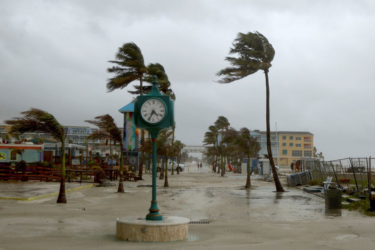
- Wind Conditions
- Forecast and Timing
Hurricane Debby is set to bring hurricane-force winds to the affected areas starting early Monday. Tropical storm conditions will commence overnight in these regions and will extend northward along the Florida Gulf Coast. By late Monday, these conditions will begin to affect parts of the Atlantic Coast and South Carolina.
- Detailed Wind Impact Areas:
-
Florida Gulf Coast: Tropical storm conditions will persist through tonight, affecting various regions along the Gulf Coast.
-
Atlantic Coast: Conditions will start to intensify by late Monday.
-
South Carolina: Tropical storm conditions are expected to develop late Monday night.
- Storm Surge
- Overview
The combination of Hurricane Debby’s storm surge and normal tide levels will lead to significant flooding in coastal areas. The extent of flooding will vary depending on the surge’s timing relative to high tide.
- Expected Surge Heights:
-
Yankeetown, FL to Ochlockonee River, FL: 6-10 feet
-
Chassahowitzka, FL to Yankeetown, FL: 4-6 feet
-
Ochlockonee River, FL to Indian Pass, FL: 4-6 feet
-
Middle of Longboat Key, FL to Chassahowitzka, FL: 3-5 feet
-
Tampa Bay: 3-5 feet
-
Mouth of the St. Mary's River to South Santee River, SC: 2-4 feet
-
Middle of Longboat Key, FL to Englewood, FL: 2-4 feet
These surges will flood areas that are normally dry, and the water levels might be even higher if peak surge coincides with high tide.
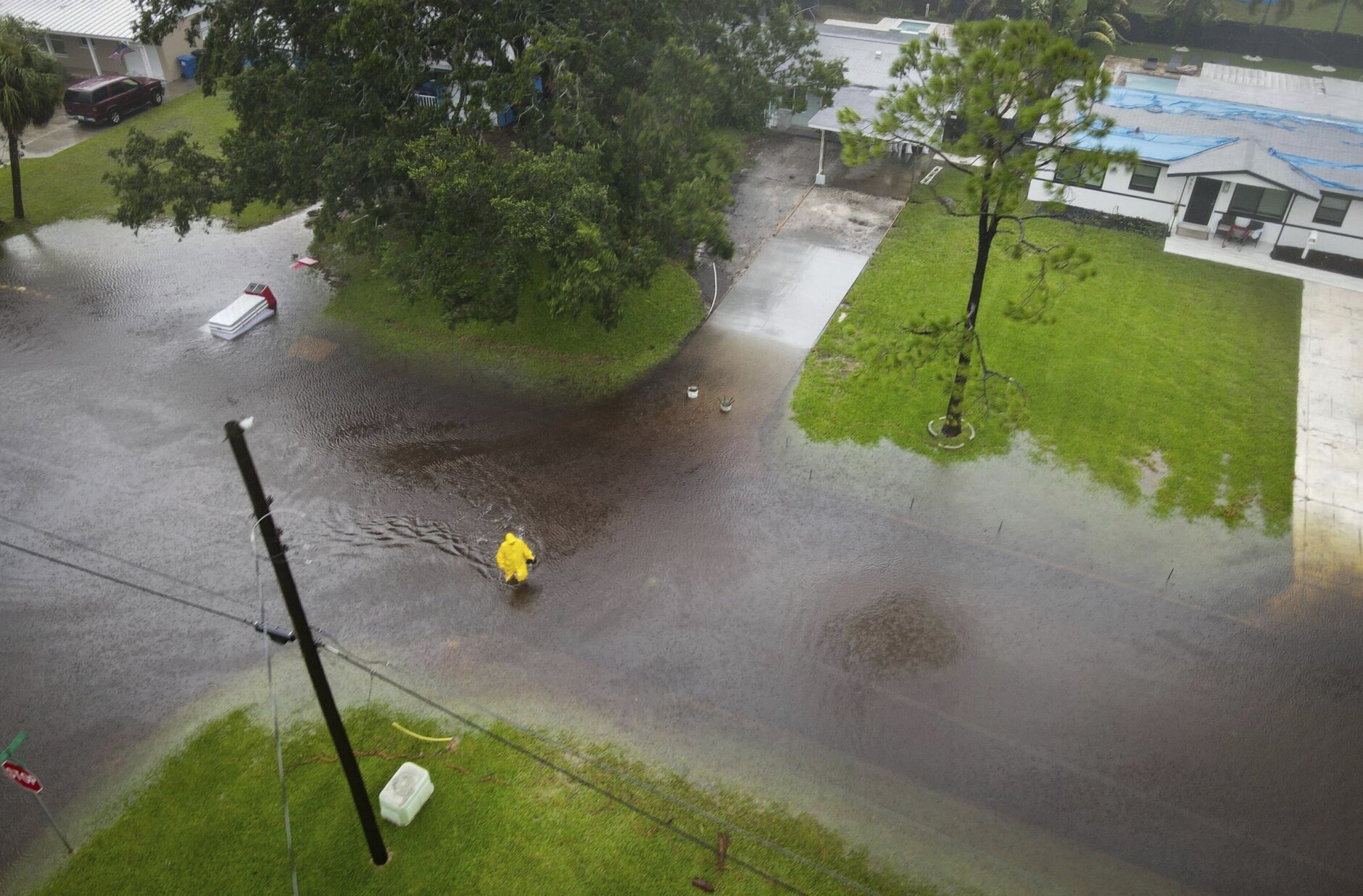
- Rainfall
- Forecast Amounts
Hurricane Debby is expected to bring significant rainfall to the region. Rainfall totals could range between 6 and 12 inches in central and northern Florida, as well as southeastern North Carolina. Localized maximum amounts could reach up to 18 inches.
- Specific Areas Affected:
-
Central and Northern Florida & Southeastern North Carolina: 6-12 inches, with up to 18 inches in some areas.
-
Southeast Georgia and South Carolina: 10-20 inches, with possible local totals reaching 30 inches.
- Potential Impacts:
This substantial rainfall is likely to cause considerable flash and urban flooding, as well as significant river flooding. The extreme amounts of rain could lead to catastrophic flooding in some areas.
- Tornadoes
There is a risk of tornadoes associated with Hurricane Debby. Tonight and Monday, a few tornadoes are possible over central and northern Florida and southern Georgia. The risk will expand northeastward into coastal Georgia and parts of South Carolina on Monday.
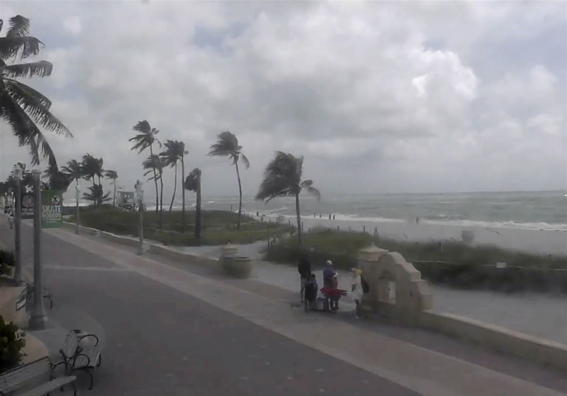
- Surf Conditions
- Expected Swells
The swells generated by Hurricane Debby will affect the Gulf Coast of Florida through Monday, with impacts continuing into the middle of the week on the Southeast U.S. coast. These swells are anticipated to create hazardous surf conditions and strong rip currents.
- Safety Considerations
The surf and rip current conditions are expected to be life-threatening, and it is crucial for beachgoers to exercise extreme caution or avoid coastal areas altogether.
➤ Key messages on what Florida can expect from Hurricane Debby
-
Historic Rainfall: Southeast Georgia and South Carolina are likely to experience catastrophic flooding due to historic rainfall amounts through Friday morning.
-
Storm Surge Danger: Life-threatening storm surge is expected along Florida's Gulf Coast, particularly between Ochlockonee River and Yankeetown.
-
Hurricane Conditions: Hurricane conditions are anticipated in the Florida Big Bend region, with tropical storm conditions extending to the Tampa Bay area and beyond.
-
Extended Impacts: Dangerous storm surge and wind impacts are expected along the Southeast U.S. coast, with warnings in place from northeastern Florida to North Carolina.
➤ Mandatory evacuations ordered for Florida counties
In light of the approaching storm, several counties in Florida have issued mandatory evacuation orders to ensure the safety of residents. Here’s a detailed breakdown of the evacuation orders currently in effect across the state.
1. Mandatory Evacuation Orders
Alachua County
-
Evacuation Order: Mandatory
-
Evacuation Information: Currently, there are no additional details provided.
Citrus County
-
Evacuation Order: Mandatory
-
Evacuation Information: A voluntary evacuation is recommended for all low-lying areas. This includes residents living in campers, tents, mobile homes, manufactured homes, or any structures unable to withstand sustained winds of up to 60 mph. Mandatory evacuation is in effect for Zone A.
Dixie County
-
Evacuation Order: Mandatory
-
Evacuation Information: Evacuations will commence at 2 p.m. on Sunday, August 4, 2024. This order applies to all coastal communities, including Suwannee, Horseshoe Beach, Jena, and nearby areas, as well as substandard housing and low-lying areas within the county.
Franklin County
-
Evacuation Order: Mandatory
-
Evacuation Information: Effective from 6:00 a.m. on Sunday, August 4, 2024, a mandatory evacuation is ordered for all barrier islands, including St. George Island, Dog Island, and Alligator Point. This order also covers low-lying and flood-prone areas, particularly along the coast and rivers, as well as RV parks. Additional evacuations may be announced if there are changes to the storm's track or intensity.
Levy County
-
Evacuation Order: Mandatory
-
Evacuation Information: Immediate evacuation is required, with completion by 8 p.m. on Saturday, August 3, 2024. This includes individuals residing in recreational vehicle parks, mobile homes, and manufactured homes, as well as residents in coastal communities and low-lying areas throughout the county.
Taylor County
-
Evacuation Order: Mandatory
-
Evacuation Information: The Taylor County Sheriff's Office has issued a voluntary evacuation order for all coastal and low-lying areas, strongly encouraging residents to evacuate. While the term "mandatory" cannot be legally enforced, residents are advised to take this warning seriously. A shelter is available at Taylor County Elementary School, located at 1600 East Green Street, opening at 4 p.m. today. Due to limited space, residents are advised to bring only essential items, and pets must be crated.
Wakulla County
-
Evacuation Order: Mandatory
-
Evacuation Information: A mandatory evacuation is in effect for Zone A and other low-lying areas.
2. Voluntary Evacuation Orders
The following counties have issued voluntary evacuation orders:
-
Clay County
-
Gadsden County
-
Hamilton County
-
Hernando County
-
Jefferson County
-
Lafayette County
-
Madison County
-
Pasco County
-
Union County
With inputs from agencies
Image Source: Multiple agencies
© Copyright 2024. All Rights Reserved Powered by Vygr Media.